If you’re a fan of road trips, then you’ve probably come across several interstate road signs while driving. Interstate road signs display the highway’s assigned number, which helps drivers navigate across state lines without getting lost. However, these numbers aren’t just randomly assigned, as they can actually tell you a lot about the road you’re traveling through.
How Are Interstates Numbered?
Each interstate is assigned a number based on several factors, and while there are some exceptions, most interstates follow the same set of rules.
Number of Digits
Based on the number of digits in the interstate’s name, you can actually deduce whether it connects several cities or only serves a single area. One and two-digit interstates span across different cities, such as the I-90 and I-95.
On the other hand, three-digit interstates are called auxiliary interstate highways. They only cover a single city, but they’re connected to longer two-digit highways, known as their parent highways. The last two digits of auxiliary interstate highways match the parent highway. For example, the I-285 in Atlanta connects to the interstate highway I-85.
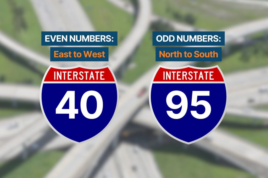
Even and Odd Numbers
Interstates with even numbers cross from east to west, while odd-numbered interstates cover north-south routes.
In contrast to the US highways’ numbering system, the numbers for east-west interstates start from the south and increase as you travel north. The numbers for north-south interstates begin from the west and increase as you reach the east.
First Digit of Three-Digit Interstates
If the first digit of a three-digit interstate is odd, then this typically means the road has one intersection. Meanwhile, even-numbered first digits intersect with their parent highway at two different points.
Exceptions
While most interstates follow these rules, there are a few exceptions. For example, an interstate in San Fransisco is named I-238 even though it doesn’t connect to an I-38. With several highways already present in California, the I-238’s original number was already taken.
What Is the Interstate System for?
In 1956, the US Congress passed the Federal-Aid Highway Act, which authorized the construction of the interstate highway system. Officially known as the Dwight D. Eisenhower National System of Interstate and Defense Highways, the US Interstate System had three main objectives:
National Defense
Before he was elected president, Eisenhower served as the Army General during World War II. He was stationed in Germany, where he saw firsthand the importance of high-speed roads.
Inspired by Germany’s Autobahn network, Eisenhower argued that interstates would benefit the country’s defense by improving transportation routes between military bases.
Quick Evacuation
With the construction of the interstate highways, citizens now had a clear evacuation route in the event of a nuclear attack or other similar conflict. Interstate highways were built to handle the mass evacuation traffic of various cities.
Efficient Travel Routes
Without intersections, interstates allowed drivers to pass through without having to stop. This is thanks to carefully mapped out underpasses and overpasses that created a seamless journey with fewer traffic jams.
Travelers aren’t the only ones who benefited from the construction of the interstates. Gas stations, bus stops, and similar types of businesses thrived after road trips became popular.
What Do Interstate Guide Signs Look Like?
With so many different types of road signs, knowing which ones are actually interstate signs can get a bit confusing.
Interstate signs are shaped like a shield with a blue background. They usually feature a red strip on top with the word, “Interstate,” printed across it. The highway’s route number is printed in the very center. Because interstate road sign fonts are typically white, they’re easy to read.
You can find highway and interstate signs at major intersections, along with other road signs that feature arrows or directions.
What Is the Longest US Interstate?
The I-90 is the longest interstate in the US. Covering 3,020 miles, the I-90 connects Boston and Seattle. It covers 13 states and connects several major cities, such as Albany, Buffalo, and Chicago. There are several attraction sites along the I-90, making it a popular road trip destination for many. Some examples include the Wall Drug, the Badlands National Park, and the Corn Palace.
Meanwhile, the interstate that crosses through the most states is the I-95. It covers 15 states, like Maine and Washington, D.C.
Other Highway Road Signs and What They Mean
Aside from interstate road signs, you’ve likely noticed other types of road signs with numbers on them. Here’s what they mean:
US Highways System
Road signs for the US Numbered Highway System are shaped like a shield and typically come in black and white. Their numbers are assigned according to rules similar to interstate signs. However, north-south highway numbers get higher from east to west, while east-west highway numbers increase from north to south.
State and Other Secondary Highways
Road signs for state, territorial, county, and secondary highways are less uniform. They tend to vary according to their respective regions, which means they can come in different shapes and colors.
Keep Reading: Related Posts


Any information provided on this Website is for informational purposes only and is not intended to replace consultation with a professional mechanic. The accuracy and timeliness of the information may change from the time of publication.